
CityStrides: my favorite connected service
30 January 2025
I came across CityStrides by accident a couple of years back, and couldn't be happier about it. This is how & why I use it.
Almost 10 years ago, in my very first post ever, I shared how I made fun "heatmaps" for my activities with uMap. At a first glance, CityStrides offers something similar in an automated (and much more professional) way. But it is so much more than that! For me at least.
What is it exactly?!
The tl;dr version is this: it is a website that tells you which streets you have trotted in their entirety. Thanks for reading, have a nice day!
If that answer does not satisfy your curiosity completely then stay a while and listen. Let me start by telling you...
How it works
First, if you haven't yet, sign up here.
Settings/Referrals)
After this first step, you have to connect to your preferred fitness tracker, as of today, these are supported:
- Garmin Connect
- Strava
- RunKeeper
- MapMyRun
- Coros
- Suunto
Having done that, CityStrides will fetch all your walking, hiking and running activities and put them on a map:
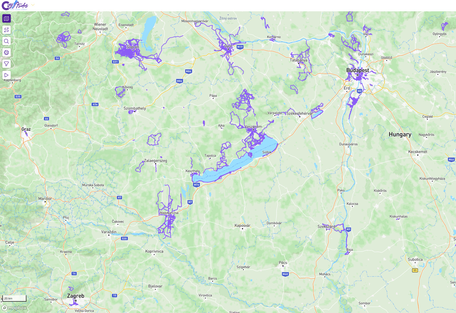
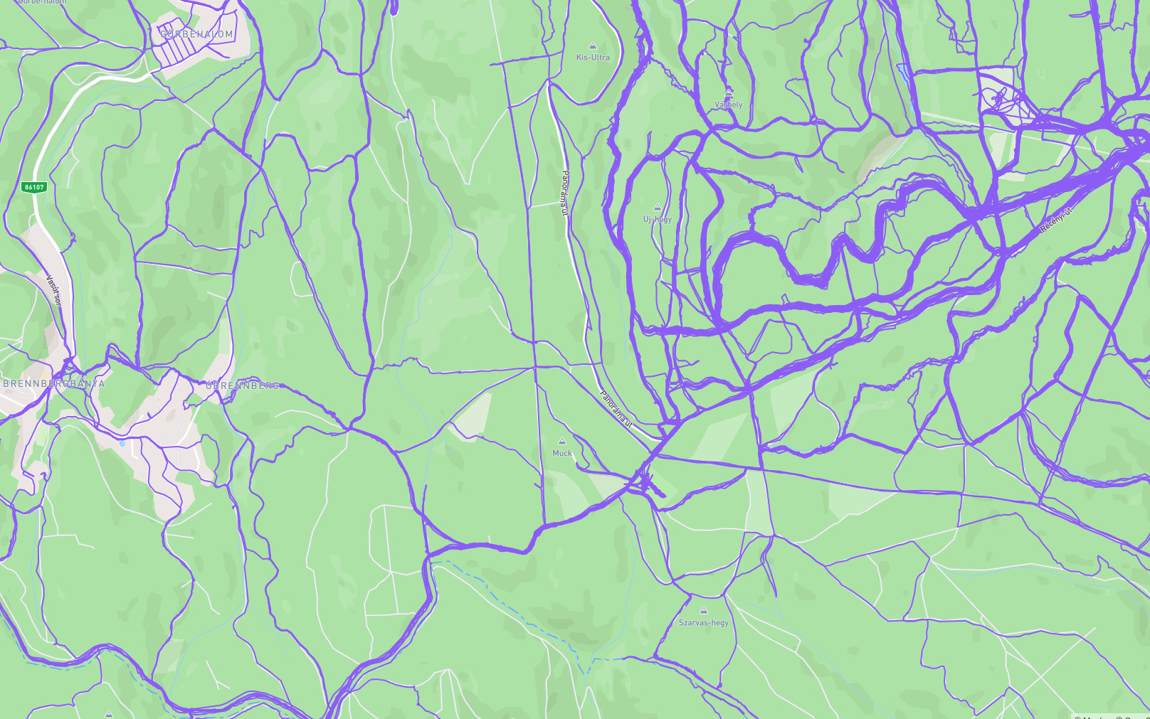
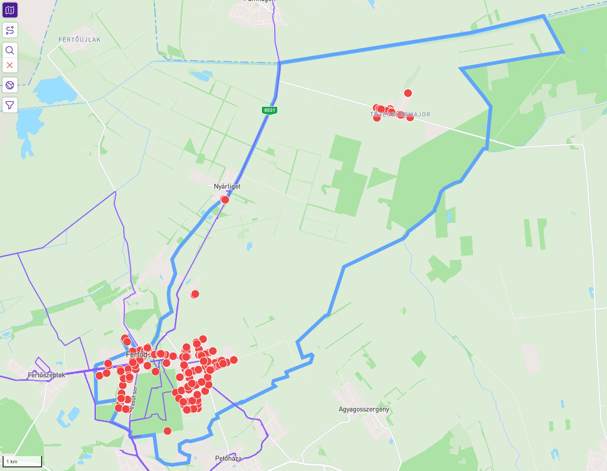
This a birds (or rather satellites) eye view mostly of western Hungary, where I had 95% of my runs. But you can zoom in to specific places pretty responsively too. This is the city (and its surroundings) where I'm currently living:
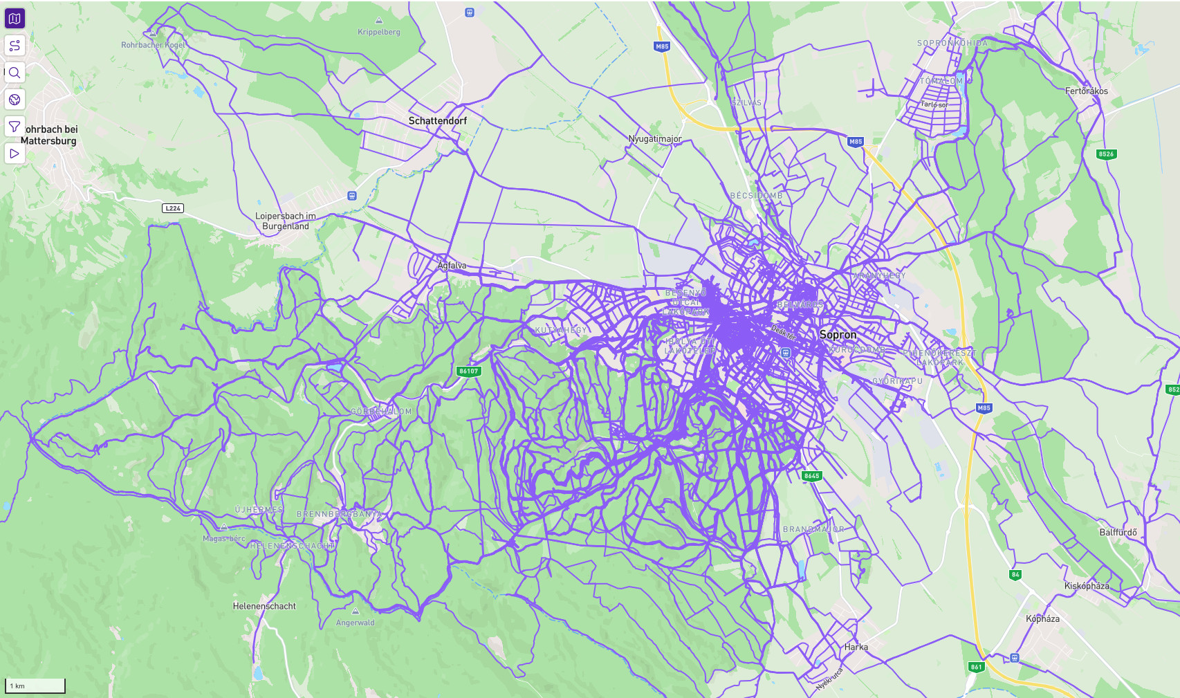
Just browsing this map can be quite entertaining in itself, but the site was originally designed to make urban running a bit more fun. Behind the scenes, the site regularly updates its database of streets from OpenStreetMap, and matches those purple lines against them. If a street becomes fully purple (either by one or multiple activities), it gets marked as completed. (The actual process is a bit different as explained in the "PRO" section below.) This is the village where my mother grew up:
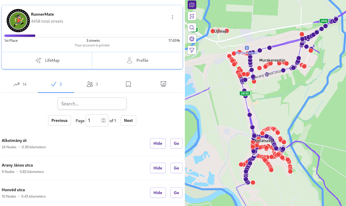
One can quickly see, that although I've been to this village countless times, I always sticked to the same streets, and most of it is completely unknown to me. I've only completed 3 of its 17 streets... Now I know what I'll do the next time I visit some relatives there. If you like numbers, achievements, etc. you may start to see, how this can be too damn exiting:
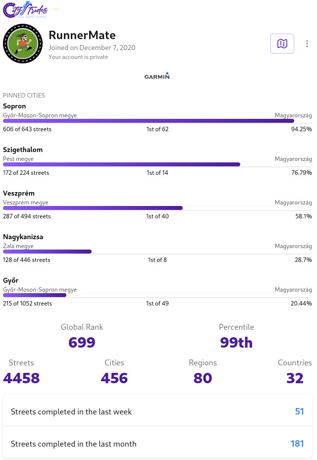
Sopron, Szigethalom, etc. are the cities where I have lived, and these are pinned on my profile, so I can see my progress there, and also my position among fellow "striders". More than that, the site maintains a global rank based on streets completed all over the world. As of today, there are 75k users, and if you think 4k streets is a lot, check out the top striders.
Now that we discussed how it works and what it does, let's talk about how I personally use it.
My CityStrides habbits
The... intended use-case
I use CityStrides to... complete streets. I know, a shocker, right? To be more specific, I mostly look at my map in the winter. For safety reasons I tend not to run alone in the forests when it is already dark, which happens a lot during the colder months. Now, some people may listen to music, podcasts or audiobooks to make urban running in ones hometown more interesting. I just look at my map, target some unvisited streets then cry about how many positions I've lost, as everyone around me did more. (To be completely honest, I also combine it with audiobooks sometimes. Why shouldn't I explore both new streets and Tel'aran'rhiod at the same time?)
Also, when I'm in a city that I frequent less, I'm more thoughtful of choosing different routes to get to the grocery store, train station, etc. Back to running: as the days get longer, city-hunting gets a backseat to trail runs. Speaking of which:
ForestStrides
Forest trails are not streets (with a few exception), and as such, one does not get any achievement by "completing" them. Still, realizing that there are unknown paths close to frequented places can happen not just in cities (see my mothers village above) but in the wilderness too:
The thickest lines above are the results of probably more than 50 passes, as these are the trails close to my place. Still, not so far from them, there are paths which I've never-ever seen.... yet. Targeting such sections is kind of a mystery box (both in the forest and in the city): it can turn out to be an unexpected gem, that I frequent in the future, or something which only checks out a box, never to be visited again.
Isolation is so 2021...
Recently, an idea of a new "goal on citystrides" has formed in my mind. The trigger was actually the sight of the very first map photo from above:
Naturally, there are some hotspots around the cities where I've lived, and they have their tentacles around them, which don't really meet up. You see where I'm getting at, right? How awesome would it be to connect all these purple islands in a spiderweb of runs? Naturally, the site does not calculate the largest connected component or largest rounded area, etc., but it would be still fun, just to see this map as a purple mesh.
Everything better with friends
All the above is nice and all, but everything is better with friends. Luckily, I could convince 3 of those strange organisms to join me. A chit-chat run can nicely be combined with completing streets together.
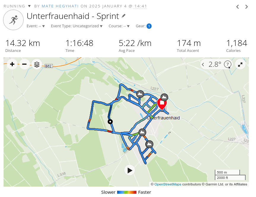
This run for example only came to be, as one of those friends wanted to have village with more than 10 streets completed to 100%. (And I had a sprint training scheduled... yeah... I wasn't so chatty.)
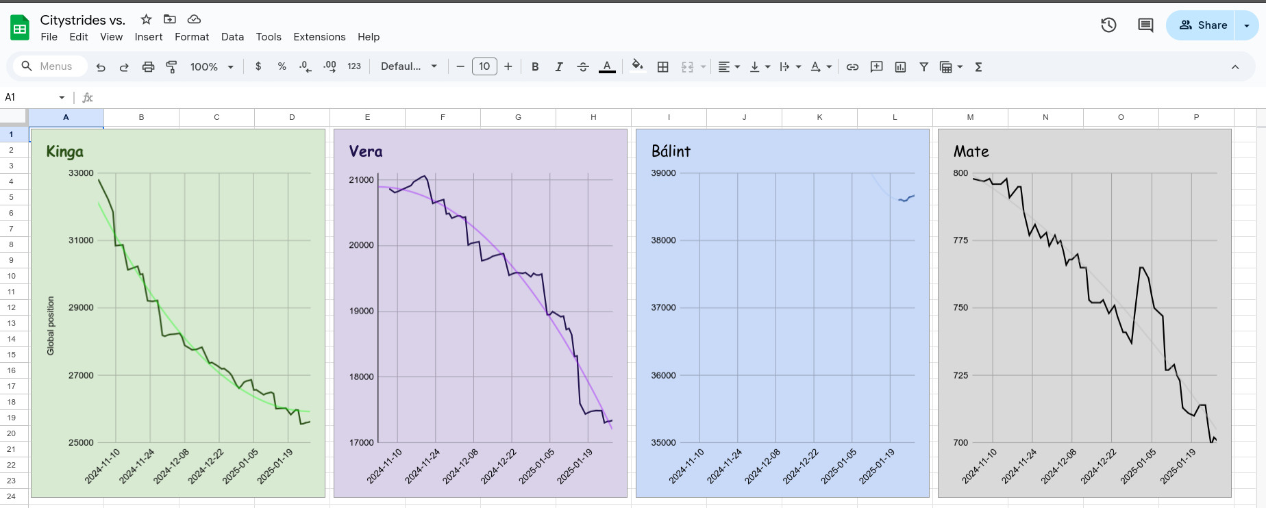
We also started to record our street count and global position (mostly) daily in a google spreadsheet to track progress. This is also fun, since inactivity doesn't mean stagnation, it means falling behind, as others prgress.
Making locals scratch their head
This is only a fun remark: thanks to CityStrides, I've received plenty of looks from the baffled-questioning spectrum when I ran into a short dead-end road just to come back a minute later... and then 50 meters away do the same with another dead-end, and again, and again. Would love to hear the reasoning they made up in their mind about me.
OpenStreetMap community service
I have found plenty of non-existing or restricted-access roads in the last few months. Although pretty annoying at the time, it motivated me to update these inaccuracies on OpenStreetMap. These were mostly very small streets or segments, and probably didn't bother anybody much, but still, OSM just got a little bit better thanks to CityStrides.
What is behind a paywall?
NOTHING that I said so far. Even in this free version the site is pretty featureful, so if you are short on money, you can have fun with the free version. Having said that, it is time to get straight to the point:
How expensive is it? - $5/month or $50/year.
Is it worth the money? - Absolutely.
So you have it? - Well, yes and no.
Let me explain: as I said above, my focus on hunting streets is kind of seasonal. So I'll probably not need the features listed below during the warmer months. I opt for the prepay option with $5/month, when I need the tools, and maybe spend some of my summer months worth on gifting months to friends. If you intend to become a hardcore (foreshadowing...) strider, go for the annual recurring option.
Huge kudos to James for allowing the prepaid option in the age of subscription-fatigue. Who is James?! The sole developer and maintainer of the site (marketing and security is outsourced to clawfficers with very strict looks). James, if you read this, thank you. Honestly.
Now let's talk features.
Node hunter
This is probably one of the two most useful "pro features" for hunting. A bit of technical mumbo-jumbo is needed to explain the first: each street from OSM is distilled down to a few significant locations = nodes in order to save storage and computational power to calculate the answer to life, universe and everything. GPX tracks of activities are matched against these nodes, and a street is marked completed if all of its nodes are visited (or veeery closely passed by). (Nodes at intersections belong to multiple streets.) The nodehunter feature let's you see all the nodes to be hunted in the selected region (up to 1000 nodes), like that:
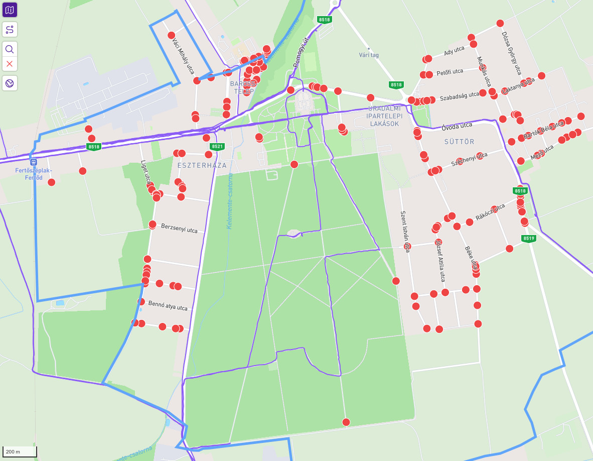
Why is this useful? This is a small town nearby, and the center is the park/garden of the Eszterházy castle. Now... would you have thought that the vertical line in the middle is actually a street according to OSM, and you have to go there to complete the town? Probably not. You can highlight the nodes of both completed and incomplete (called progressed on the site) streets one-by-one manually in the free version, but that is pretty cumbersome. When you get to a new city, and have an "empty canvas", you don't really need this, but as you progress, finding these nasty hide-and-seek playing dots becomes troublesome without nodehunter.
Wait, you didn't know that Tőzeggyármajor officially belongs (blue border) to Fertőd (from the previous photo)? Too bad... Unless you have nodehunter.
Yes, a bit inaccurate borders and the selection of nodes can result in quirky edge cases / mistakes. Moreover, one may complete short streets if they are only represented by crossing nodes at their ends. But.. in the end... it is just a game for fun. Don't take it too seriously. "Fixing" these is definitely not worth the effort if even possible.
Route planner
Along with nodehunter the on-map route planner is the most useful supporter feature according to my opinion.
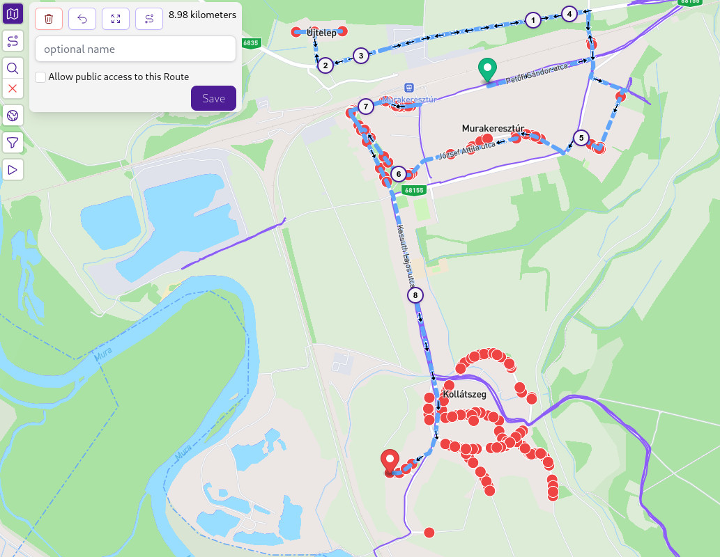
This shows the intermediate state of planning a route to complete my mothers childhood village. The route editor is not as advanced as that of Garmins, you can't drag/edit existing segments only undo them. But it is perfect for the purpose, you can export the route in GPX format, get it to your watch and go striding.
When I was only an occasional strider, didn't have supporter features, I'd have my CityStrides lifemap on the left monitor, and the Garmin Connect course planner on the right one. Doable, but if you do this 2-3 times a week, the saved time and trouble is worth the 5 bucks.
The rest
There are several other nice features for supporters, definitely check out the linked list. (Yes, I'm fun at parties.) But to be honest, I mostly care about the above two, and this post is already way too long. Just as an example, having an animation of your progress in a city is also pretty fun. Here is a recording of the same western region of Hungary as in the beginning. You can pretty much follow, when I moved to new cities.Long story short, if you have the means, and use the site extensively, I highly encourage you to become a supporter for your active months. It would be a pity to see this site go for financial reasons. If you are interested in physical mementos, check out the merch store as well.
Anything else?
Nah, I think I'm sleepy enough. Thanks for reading this far, hope you enjoyed it, or at least found something fun to do. It is crazy, that I haven't posted anything for 2.5 years, but this was definitely something I wanted to talk about, as I did that with couple of friends irl recently. And I'm lazy, so from now on I can just share the link. Aaaanyhow, see you on the streets stridin'.